
Part 2 – Clearings in the Woods
When, around AD 650, the first Anglo-Saxon settlers arrived, the land they wanted to farm would mostly have been woodland, so the first job was to clear it. The suffix “-ley” is associated with clearings, as in Gamesley – Gamel’s clearing; Simmondley – Sigmund’s clearing.
They would then plough a field – Padfield, probably Padda’s field. Each community would have been very small to begin with, possibly just one extended family, so would have worked the land as a group, and that practice continued even as it grew, as heavy ploughs and teams of oxen were expensive and villages could often afford only one. After ploughing, the field would be divided in strips between the families, each getting a fair share of the best land, and over the centuries more fields would be cleared.
Oxen were sluggish beasts, and once up to speed it was best to keep going, so the fields were very long. A large team also needed a lot of room to turn, so the ploughman would first have to send it one way before circling round the other way to come back down the field, the result being an elongated S shape. When, 1,000 years after the first arrivals, collective farming was finally abandoned, the owners of the strips put walls round them, creating “fossil open fields”. Chunal (see picture, 1857) is a good example, but they can be seen also in Hadfield, Padfield, Charlesworth, Whitfield and Simmondley on maps drawn before modern housing development. We’ll come to (Old) Glossop later.
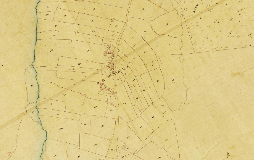
Further south, open fields often filled almost the entire area of a village, but here most land remained woodland or open common. Soil and climate weren’t good for growing crops, so villagers would have depended heavily on livestock pastured on the common or on the stubble after harvesting. In 1066 Padfield had the largest area of arable, one carucate, a nominal 120 acres although probably much less, but a huge area of common stretching right up the valley to Saltersbrook.
Sharing of land and tillage required rules, and people who could enforce them. We don’t know whether the villages had an overlord when founded, but there’s evidence that by the 700s they were part of a large estate based on Mottram including the whole of the Longdendale valley. By 1066, though, the Anglo-Saxon kings had divided the area between their new counties, and the villages on the Cheshire side of the river were held by the Earl of Chester, those in Derbyshire by several freemen, the biggest being one Leofing who held Padfield, Glossop and Whitfield. He would, though, have been a farmer like everyone else, just with a bigger house.
Even after 400 years the villages would still have been very small, just little clusters of windowless huts made of wood, mud and thatch, surrounded by their open fields but separated from their neighbours by large tracts of woodland, heath and boggy valley floors, and the total population was probably little more than 300. However, 1066 was a high point; disaster was about to strike, from which full recovery took at least 200 years. Next time we will look at what happened, and what followed.