
Part 9 – (Old) Glossop
The Anglo-Saxons, who were practical people, would have known that in rainy west-facing hills, valley floors were not a good place to settle; even above the flood line they might be boggy or choked with dense woodland. As a result, the centres of the “Domesday villages” are all up on the hillsides, at least 65 feet above the nearest major stream.
Except one. The centre of what we now call Old Glossop is just 10 feet above Shelf Brook and Blackshaw Clough as they would have been before they were dug out and straightened in the late 18th century (and the brook ran then where the Queens Arms is now). Even in the 21st century there have been floods, so you can imagine what it would have been like in the Middle Ages after a cloudburst over Shelf Moor. And this was the main urban centre of the manor, with shops, tradesmen and manor officials.
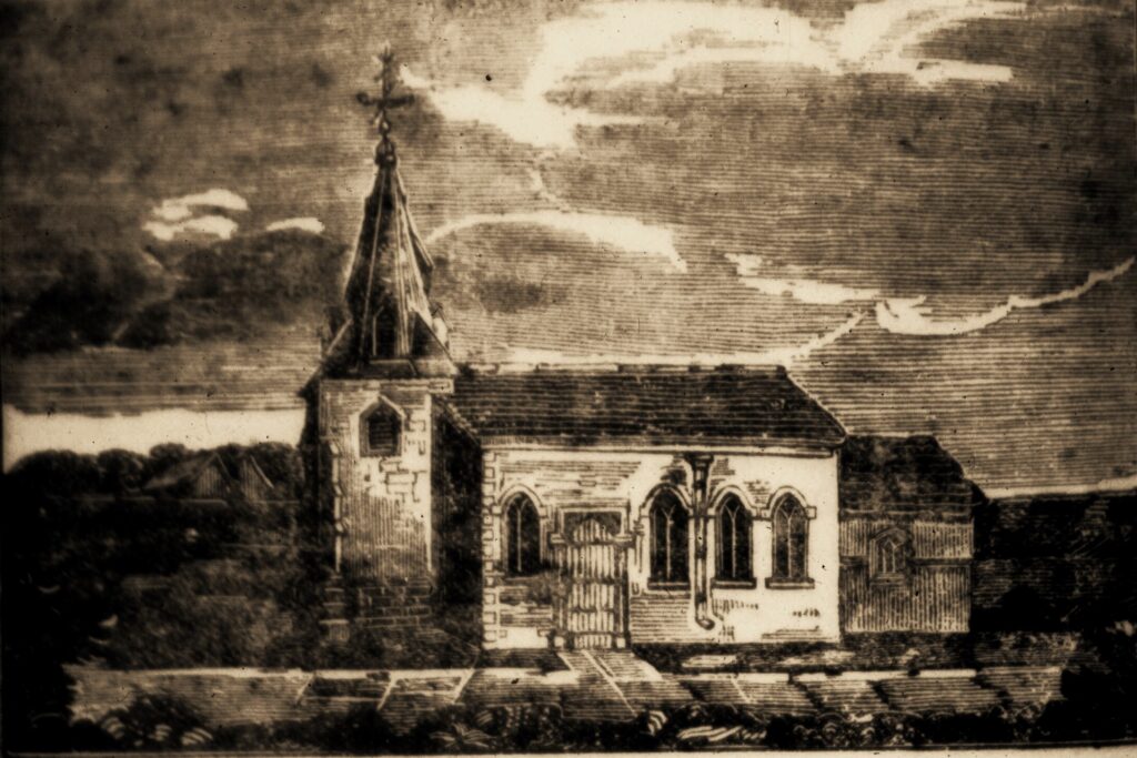
Why? Well, Glossop became the urban centre because it had the church (see pic, pre 1831). It was there when the monks arrived, and the assumption has been that it was built by the Peverels after 1066. However, that seems doubtful, as the population was still virtually nil in 1086 and would have recovered only slowly in the Royal Forest. More likely that it was built before the Norman Conquest. Although it wasn’t mentioned in Domesday, neither were many known Anglo-Saxon churches.
Whenever, though, the village would already have been well-established. The original settlers were almost certainly pagan, and once converted would have been served initially by travelling bishops. Squeezing a church, with its burial ground, into an existing settlement could be difficult, so better to use the nearest patch of common land.
The logical place for the original village would have been what’s now Castle Hill, a safe 30 feet above the brook. We know there were open arable fields, but aren’t sure where, but the most likely areas are to the west, north and east of that site. The lower ground to the south, when cleared of trees, was “warth”, meadowland close to a stream, so open land which could be built on if firm enough.
Once the church was there, it would become a focal point – the one building in which the whole community could meet. After 1157 it would also become the centre of the Abbey’s new manor, and in 1291 a market was established next to it, around which traders would build houses. Where, therefore, the centres of the other villages were determined by the location of their open fields, that of urbanised Glossop was fixed by the position of the church.
The Abbey’s work was mostly done by its lay brothers or tenants, but the church meant at least one resident ordained monk, who would have had frequent run-ins with the Forest officials. The crunch came in 1285 when the Abbot was fined for cutting down trees on Shelf Moor, but he eventually persuaded the King that he had a right to do so, thereby clearing the way for a sheep run in that area, the boundary wall of which can still be traced running below Shelf Benches. Last year traces of a large enclosure, 250 feet square, which is likely to date from this era, were spotted on Lidar at Yellow Slacks.
The trees in dispute were used to construct a building which has been described as a produce barn, but which measured 100 by 15 feet which suggests that it wasn’t just a barn, but a “longhouse” farm with produce, cattle and farmer all under one roof. Its location is unknown, but until the late 18th century the vicar, successor to the resident monks, was still living next to the church in a decrepit wood-framed building complete with stable, cowhouse and small barn, estimated size 50 by 16 feet. Might the main timbers at least have dated back to 1285?
Although there’s still one farm in the village itself, by the 17th century there were at least 10 satellites, some of which, like Blackshaw and Heath, may well date back to monastic times; it made sense for the monks to outpost tenants to self-contained farms rather than try to manage from the village flocks of cattle and sheep roaming semi-wild across open common. Around 1580 the open fields were also enclosed, then the Howards, who replaced the Talbots in 1606, made it their base rather than Simmondley, and from then on the centre became increasingly urbanised and focussed on textiles more than agriculture.
However, to this day the village has retained its original name virtually unchanged. It was Glosop in Domesday, which by consensus started out as Glott’s hop – Glott’s valley – and if the valley belonged to Glott, perhaps he was the leader of the original band of Anglo-Saxons who settled in this area nearly 1400 years ago.
END OF SERIES
PREVIOUS – Part 8 Whitfield